1-3
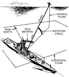
Figure 1-2.—Radar reference coordinates.
This second plane is called the VERTICAL PLANE. The radar location is the center of this
coordinate system. The line from the radar set directly to the object is referred to as the LINE OF SIGHT
(los). The length of this line is called RANGE. The angle between the horizontal plane and the los is the
ELEVATION ANGLE. The angle measured clockwise from true north in the horizontal plane is called
the TRUE BEARING or AZIMUTH angle. These three coordinates of range, bearing, and elevation
describe the location of an object with respect to the antenna.
Q1. Radar surface-angular measurements are referenced to true north and measured in what plane?
Q2. The distance from a radar set to a target measured along the line of sight is identified by what
term?
RANGE
Radar measurement of range, or distance, is made possible because of the properties of radiated
electromagnetic energy. This energy normally travels through space in a straight line, at a constant speed,
and will vary only slightly because of atmospheric and weather conditions. The effects atmosphere and
weather have on this energy will be discussed later in this chapter; however, for this discussion on
determining range, these effects will be temporarily ignored.
Electromagnetic energy travels through air at approximately the speed of light, which is 186,000
STATUTE MILES per second. The Navy uses NAUTICAL MILES to calculate distances; 186,000
statute miles is approximately 162,000 nautical miles. While the distance of the statute mile is
approximately 5,280 feet, the distance for a nautical mile is approximately 6,080 feet.
Radar timing is usually expressed in microseconds. To relate radar timing to distances traveled by
radar energy, you should know that radiated energy from a radar set travels at approximately 984 feet per
microsecond. With the knowledge that a nautical mile is approximately 6,080 feet, we can figure the
approximate time required for radar energy to travel one nautical mile using the following calculation: